PSA!!!!
Hello Camden Residents, I wanted to post a reminder that, with the holidays approaching, there will still be availability for Special Pick-Ups. But please try to get your pick-up called in the week before the holidays, to make sure you're on the list to get picked up as soon as possible before the holidays.
Don't forget that everything has to be separated into its own pile. pine straw and leaves also have to be bagged. (THIS IS NOT CONSIDERED AS REGULAR RESIDENT TRASH PICK-UP)
The charge will be added to your water as usual.
-The first ten minutes are a $10.00 charge. If the pick-up is longer than 10 minutes, an additional charge of $0.75 per minute will be added to whatever you are charged for during the pick-up.
Please call your pick-up into Public Works at 870-837-5500
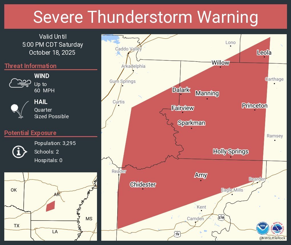
The National Weather Service has issued a Severe Thunderstorm Warning for northern Ouachita County until 5:00 p.m. Saturday.
60 mph winds and quarter-sized hail are likely. Damage to roofs, siding, and trees is expected.
For your protection, move to an interior room on the lowest floor of the building you are in.
60 mph winds and quarter-sized hail are likely. Damage to roofs, siding, and trees is expected.
For your protection, move to an interior room on the lowest floor of the building you are in.

The City of Camden Police Department is hiring. The subsequent entry-level testing will take place on October 11, 2025, at 8:00 a.m. at the Police Department, located at 1 Police Drive. To register for the test, please call the Camden PD at 870-836-5755

Camden Fairview`s Homecoming Parade for this year will be this Friday, October 3RD, at 3:00 p.m. downtown.

The Camden Police Department will conduct testing on September 6 at its location at #1 Police Drive.
Applications may be picked up at the Camden PD and must be returned no later than September 4th.
Applications may be picked up at the Camden PD and must be returned no later than September 4th.

🚨 Traffic Alert 🚨
Camden Police Department is currently working a two-vehicle accident at the red light of Cash Road and Highway 278.
➡️ Cash Road is blocked at this time. Please use alternate routes.
➡️ There are no injuries reported.
➡️ The small transport bus involved had no passengers on board.
We will provide an update once the roadway is clear. Thank you for your patience and drive safely.
Ouachita County Judge Robert McAdoo has issued a burn ban for all of Ouachita County until further notice. All outdoor burning is prohibited.
The traffic light at California & Washington (by the Post Office) is out at this time. Please treat this as an all way stop until it is working again.
Please avoid Mt Holly Rd in the are of Camden Iron & Metal at this time due to a fire. Fire Department and Police are both on scene at this time.
A Severe Thunderstorm Watch is in effect until Sunday 2:00AM for Ouachita County.
Camden and the surrounding area Launch Community Housing Study Survey to Support Future Growth
Camden, Arkansas 5/23/25 — The Ouachita Partnership for Economic Development (OPED), Housing Committee is launching a Community Housing Study Survey to understand better the current and future housing needs of our area. This vital initiative will gather feedback from residents, workers, and stakeholders to help guide planning decisions and support sustainable growth in our community.
Why the Survey Matters
As our area continues to grow and evolve, ensuring access to quality, affordable, and appropriate housing for all residents is a top priority. The survey will provide valuable insights into:
• Current housing challenges facing residents
• The types of housing needed now and in the future,
• Preferences for housing location, design, and affordability
• How housing intersects transportation, jobs, and community services
“Our goal is to make informed decisions that reflect the real needs of the people who live and work here,” said James Lee Silliman, Executive Director of OPED. “Whether you’re a homeowner, renter, business owner, or planning to move to our community, your input is critical.”
Planning for Growth
The data collected through the survey will be used to shape housing policies, guide development strategies, and support grant applications for funding future projects. It will also help ensure that housing growth is aligned with plans for infrastructure, transportation, and community services.
How to Participate
The survey is open from 5/27/25 to 7/1/25 and can be accessed online at the following website:
www.explorecamden.com
Or by entering the following into your search bar.
https://www.surveymonkey.com/r/CamdenARCommunityHousingSurvey
The survey can also be accessed by scanning a QR Code on paper copies available at area restaurants, churches, businesses, clinics, hospitals, libraries, East Camden businesses, OPED, the Camden Chamber, Camden City Hall, East Camden City Hall, and the County Courthouse. The survey link will be posted on social media, as well as on the City of Camden's, the Ouachita Partnership for Economic Development's, and the Camden Regional Chamber of Commerce's websites. All responses are confidential, and the survey takes less than 10 minutes to complete. To participate, one must be a resident of Ouachita County, 18 years or older.
Let Your Voice Shape the Future of the Camden area.
Everyone deserves a safe, suitable place to call home. By participating in the Community Housing Study Survey, residents are helping build a stronger, more inclusive community for today—and for generations to come.
For more information, contact: James Lee Silliman, Executive Director, 870-836-2210
director@teamcamden.com oped@att.net www.explorecamden.com

Please avoid Dallas Ave from Clifton Ave to the dead end as we have trees down.
We have high water with washing of the roadway near the intersection of Tate Street & Avon. Please use alternate route at this time.
TRAFFIC ADVISORY - AVOID MONROE STREET NEAR FORT LOOKOUT 🚨
Due to heavy rainfall, there is water over the roadway on Monroe Street near Fort Lookout. Please avoid this area and do not attempt to drive through high water. It only takes a few inches of water to lose control of your vehicle or become stranded.
Barricades will be placed in this area. For your safety and the safety of our officers, please respect all road closures and detour signs.
🌧️ Rainy Weather Driving Tips:
• Slow down. Wet roads reduce traction.
• Turn on your headlights so other drivers can see you.
• Keep a safe distance between you and the car in front of you.
• Avoid sudden stops or sharp turns.
• Never drive through standing water. It can be deeper than it appears.
Let’s all do our part to stay safe on the roads. Thank you for your cooperation, Camden!
— Camden Police Department
We are experiencing flooding on Grinstead in the area of the railroad track. Please use alternate route at this time.
The National Weather Service has issued a Flash Flood Warning for Ouachita County until 9:45 p.m. Sunday.
TURN AROUND, DON'T DROWN!
Doppler radar has estimated up between two and four inches of rain have already occurred in this area, with several additional inches of rain expected. Flash flooding of small creeks and streams, ditches, and other low-lying areas is already ongoing or likely to occur shortly.
Use caution when traveling, and don't drive through floodwaters of any depth, as roads may be compromised.
Flooding is the leading cause of weather-related deaths, with most flood-related deaths occurring in vehicles. Flooding is especially difficult to see at night!
The National Weather Service has issued a Severe Thunderstorm Watch for Ouachita County until 9:00 p.m. Sunday.
Primary threats include:
•Large hail of up to 2 inches.
•Damaging winds up to 70 mph.
•A possible tornado or two.
To receive free weather alerts sent to your mobile phone or landline, sign up for CodeRED alerts on our website at: www.camdenfd.com/severe-weather
A Severe Thunderstorm Watch means conditions are favorable for severe thunderstorms in and close to the watch area. If you are in the watch area, be sure to monitor the National Weather Service, your NOAA Weather Radio, or local news for more information on threatening weather conditions and additional severe weather watches or warnings.
Cash Rd in the area of Camden Fairview High School is experiencing flooding at this time. Please use caution.
The red light at US 278 Bypass & Cash Rd is currently blinking. Please treat this as a 4 way stop at this time.
Be advised, we are experiencing flooding on California Ave in the area of the Police Station. Please use caution when driving during thunderstorms.